How to find us
The Faculty of Social Sciences is located at the former municipal hospital of Copenhagen (Kommunehospitalet) right across from the Botanical Garden and next to the inner Copenhagen lakes. To day campus is referred to as Centre for Health and Society (Center for Sundhed og Samfund in Danish, abbreviated CSS).
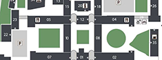
Please view the below maps in order to find your way around campus:
- Campus map (pdf-format)
- Google map - University of Copenhagen
Office numbers contain the all necessary information about building number, floor and room number that is needed to find any room on the premises.
First digit indicates building number, second digit indicates on which floor the room is located and the third digit is the room number, e.g. 5.1.46 means that room 46 is located in Building 5 on the 1st floor. If the room number says 01 in the second digit, it means that the room is located in the basement.
Arriving by bus
Bus number 14 has a stop right outside the Faculty on Øster Farimagsgade.
Arriving by Metro
The metro station closest to the Faculty of Social Sciences is "Nørreport". From there it is a 10 minute walk to the Faculty.
The Metro runs day and night. At rush hours (between 7-10 and 15-18) the intervals between departures are 2-4 minutes. Outside rush hours the intervals are 3-6 minutes.
More information can be found at the Copenhagen Metro's website.
Arriving by car
All parking spaces at the CSS/municipal hospital need payment from January 1 2023.
Apcoa is responsible for administering the parking licenses. Via the APCOA FLOW app you can buy a license for any parking space for one month at a time for a fixed number plate. Paid parking on an hourly basis is via the APCOA FLOW app or via Easypark.
UCPH is not responsible for the parking scheme.
As with other parking spaces, you are encouraged to inform yourself of the parking rules, which are stated on signs throughout the area.
Parking at Øster Farimagsgade 2A is reserved for staff at the Department of Psychology and requires a special permit. Find out more on KUnet about how to obtain a parking permit.
See the location of parking spaces on the map of CSS.